"The Ships"
- featuring SKA 4 - page three -
- incl. her sister ships, crew and Greenland -
")
SKA 3 (Photography by Karsten Petersen ©)
")
SKA 4, - and Jørgen watching the echo sounder (Photography by Karsten Petersen ©)
A good picture of what it is all about - - -
The four SKA boats would usually sail side by side keeping a fixed distance from each other, - one of the boats being the leader, taking care that the correct position was maintained by reading the signals from the transmitter on the known position on the island - - -
How did the other boats keep the correct distance from the leader?
Well,- it was done extremely primitive compared to modern days satellite navigation, simply by having somebody watching the neighbour boat through an optical distance measuring device, - a sort of prism -, where you would see two images of the next boat if the distance was not correct - - -
Then you would advice the helmsman to go closer or further away, until you saw only one image in the handheld prism.
One image was the indication, that the distance was correct - -
At certain intervals, the lead boat would advice the other boats to draw a vertical line on the echo sounder print, - and mark it -, so that later it could be identified and compared with the lines from the other boats taken at exactly the same time.
Then later again, - when new charts was going to be made in Copenhagen -, the rolls of echo sounder paper from the four boats was compared, and the data from each boat taken at the same time, could be plotted into the chart - - -
On the picture above, you clearly see the echo sounder print with several such vertical lines - - -
Also take note of the curve the echosounder is drawing on the print. It is quite a dramatic picture of the sea bottom below, showing a wall coming up from the deep - - -
")
SKA 5 - under way to a new survey area - (Photography by Karsten Petersen ©)
Take note of the look out in the front of SKA 5 - - -
This is because the echo sounder was mounted about mid ships, and therefore reading only the depth from that point.
However,- the details of the Greenland sea bottom is quite dramatic, with holes, valleys and vertical walls, and the depth could actually go from 100 meters to 0 meters just within a few meters - - -
Therefore the boats often ran aground even though the echo sounder showed plenty of water under the keel - - -
And therefore a look out was very often the best solution in waters still not surveyed - - - Old fashioned???? Yes indeed it is,- but it works - - -
")
SKA 4, - moored at an island -, and Preben standing by on deck - (Photography by Karsten Petersen ©)

SKA 4 , - and Walseth and Preben - some measuring equipment, - a "hydrodist" -, is arranged on the aft deck - (Photography by Karsten Petersen ©)

- Jan Walseth operates the "hydrodist" distance metering equipment from the aft deck of SKA 4 - (Photography by Karsten Petersen ©)
I remember that two different distance measuring systems were used to determine our position, - the "raydist"- and the "hydrodist" system.
The "raydist" stations we erected on small islands and rocks were basically tall radio masts, and the principle was that these antennas would continuously emit different signals which could be received on the leading SKA boat.
Depending of the distance from the transmitters, the signals would have a difference, and when those different signals were compared, it was possible to calculate how far the SKA boat was from the base station.
The other system, - "hydrodist" -, could measure the exact distance between two points. What exactly the principle was with "hydrodist" I cannot remember anymore, but I am quite convinced, that the instrument that Walseth "plays" with on above picture is a "hydrodist" - - -
SKA 4 - safely parked at the island for "hydrodist" measuring - (Photography by Karsten Petersen ©)
")
SKA 4 at anchor for the night in a Greenland fjord - - - (Photography by Karsten Petersen ©)
")
SKA 3 and SKA 6 turning and preparing for surveying a new lane - (Photography by Karsten Petersen ©)
")
SKA 3 in front and SKA 6 behind during survey along a magnificent coast line. - (Photography by Karsten Petersen ©)

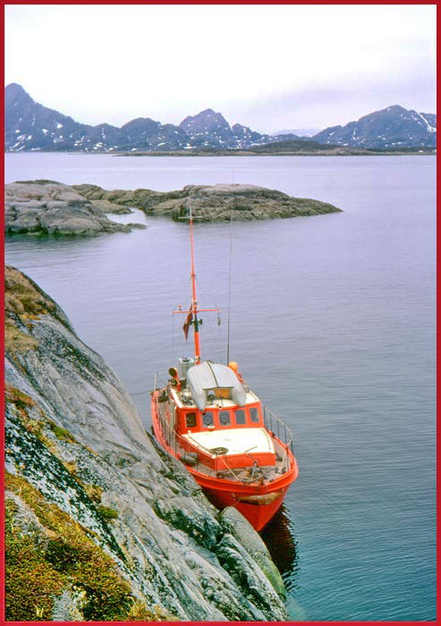
SKA 4 at anchor at a remote island where a "raydist" base has to be established - a lonely fisherman tries his luck - (Photography by Karsten Petersen ©)
")
Landing on the island - very slippery - (Photography by Karsten Petersen ©)
")
SKA 4 at anchor - view from top of the island - (Photography by Karsten Petersen ©)
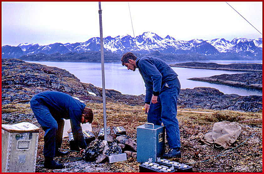
"Raydist" station This is a "green station", - and Jan Walseth and electronic wizard Jørgen putting the bits and pieces together - (Photography by Karsten Petersen ©)
")
Peter the Cook, - with dinner - (Photography by Karsten Petersen ©)
")
SKA 5 running aground in a narrow passage - (Photography by Karsten Petersen ©)
")
SKA 5 aground - SKA 6 coming to the rescue and trying to pull her free - (Photography by Karsten Petersen ©)
")
Navy boys, - SKA sailors - (Photography by Karsten Petersen ©)

Rubber boat ready with lots of "hydrodist" equipment - (Photography by Karsten Petersen ©)
")
Anchor away - - Preparing for a new day's survey - (Photography by Karsten Petersen ©)
")
Shore trips always resulted in something interesting - here finding and exploring an old tomb site - (Photography by Jan Walseth ©)
")
Skeleton parts everywhere, - just hidden in small holes in the ground covered with rocks - (Photography by Jan Walseth)
This was the end of page 3 - - - Please continue to page 4 - - -